The volcanic origin of the flower island
Madeira is the main island of the Portuguese archipelago with 741 square kilometers. This also includes the also inhabited sister island Porto Santo (45 square kilometers) and the three small, uninhabited and protected Ilhas Desertas (1,4 square kilometers). Madeira is located at about 17 degrees west longitude and around 33 degrees north latitude in the middle of the Atlantic Ocean, about at the height of the port city of Casablanca in Morocco.
The uninhabited Selvagens archipelago, which consists of 3 islands and a rocky reef and is also under nature protection, is located between Madeira and the Canary Island of Tenerife. These islands do not belong geographically to the Madeira archipelago, but are administratively attached to it.
Just like the other Atlantic archipelagos (Azores, Canaries, Cape Verde), Madeira is of volcanic origin. In the Cretaceous Period (approx. 136 to 65 million years ago) and in the Tertiary (approx. 65 to 2 million years ago) there was a so-called “hot spot” under the archipelago. This ensured a constant supply of magma. Several eruptions of the deep sea floor gave rise to two huge volcanoes that appeared around 20 million years ago above sea level. These two volcanoes were Madeira (with the Desertas) and the island of Porto Santo. In between there is a trench more than 2.300 m deep. Due to the slow migration of the continents, the continental drift, this “hot spot” has moved on and is no longer under Madeira. The last eruptions were around 1.000 to 2.000 years ago, no further volcanic eruptions are to be expected.
The former shield-shaped surface of the volcano can only be guessed at today - for example on the Paúl da Serra plateau. With their raging tides, mountain streams have cut deep gorges into the volcano and the surf of the Atlantic also ate its way into the mountain, so that Madeira is only a volcanic ruin. However, as a result of the erosion, types of rock from the volcanic interior are exposed. The basalt layers, the former lava flows, are dark, the tuff, the ash, is reddish.
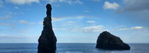
The highest mountains on the island are made of very hard basalt rock and have therefore not yet been destroyed by erosion. The soft tuff rock was more easily removed by the mountain rivers and the sea, and so bizarre rock formations and cliffs emerged, such as Cabo Girão, one of the highest cliffs in the world. About 2 million years ago there were more volcanic eruptions, especially near Funchal, Caniços and the Ponta de São Lorenço peninsula. You can still see smaller volcanic cones here today. Where the lava flowed towards the sea, the soils are particularly fertile and are used for cultivation. Where the lava flows poured into the sea, natural sea pools were created, as you can see in Porto Moniz on the north coast, for example.